Meridian
Meridian MS70
Escáner LiDAR SLAM portátil para nube de puntos 3D a color, obra civil, interiores y as-built.
$130,000.00$109,000.00 MXNIVA incluido
En stock
Ver equipo

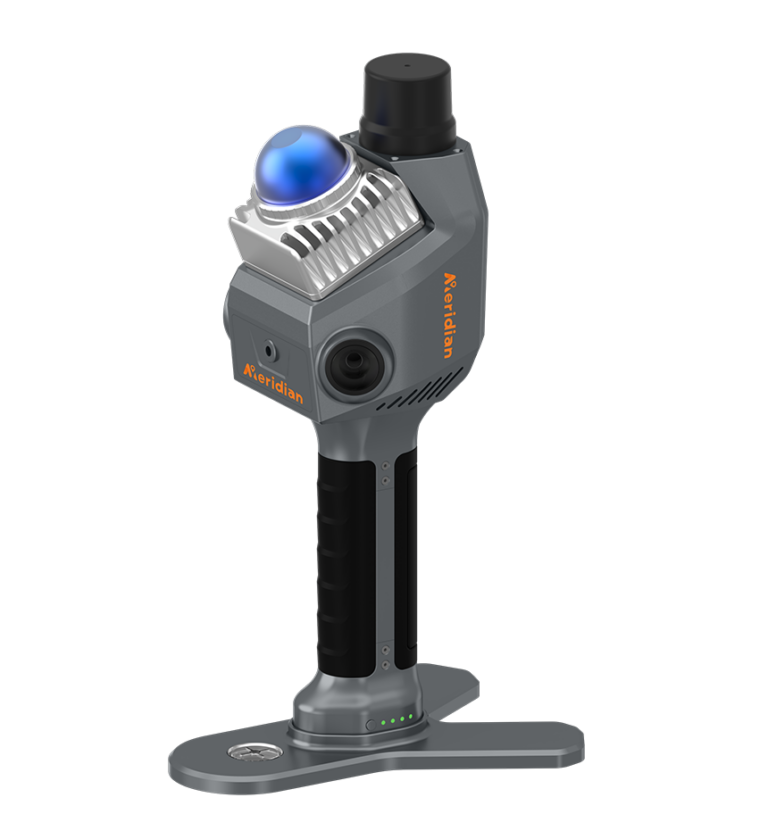
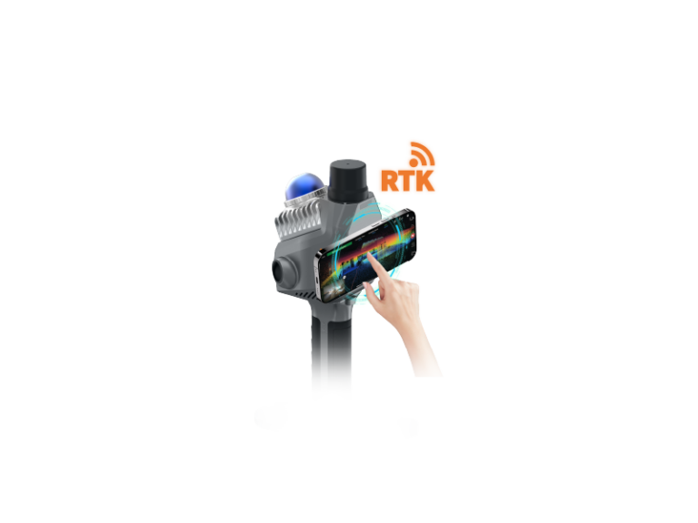
El Alpha-GEO Falcon X es un sistema de medición híbrido que combina tecnología GNSS RTK con escaneo LiDAR SLAM en un solo equipo portátil. Esto permite capturar nubes de puntos georreferenciadas en tiempo real tanto en exteriores con cielo abierto (modo RTK) como en interiores, túneles y espacios sin señal GNSS (modo SLAM). Con una velocidad de 200,000 puntos por segundo, triple cámara para navegación AR y nubes de puntos en color real, el Falcon X redefine los flujos de trabajo tradicionales de topografía, eliminando la necesidad de postprocesamiento.
Te respondemos en horario laboral. También por correo: info@geomapmx.com
[et_pb_section fb_built="1" _builder_version="4.16" custom_padding="0px||||false|false" global_colors_info="{}"][et_pb_row _builder_version="4.16" background_size="initial" background_position="top_left" background_repeat="repeat" width="100%" custom_padding="0px||0px||false|false" global_colors_info="{}"][et_pb_column type="4_4" _builder_version="4.16" custom_padding="|||" global_colors_info="{}" custom_padding__hover="|||"][et_pb_wc_cart_notice _builder_version="4.27.5" background_color="gcid-357167ea-aaab-46fc-adac-46f415c3d8c7" global_colors_info="{%22gcid-357167ea-aaab-46fc-adac-46f415c3d8c7%22:%91%22background_color%22%93}"][/et_pb_wc_cart_notice][/et_pb_column][/et_pb_row][et_pb_row column_structure="1_2,1_2" _builder_version="4.16" background_size="initial" background_position="top_left" background_repeat="repeat" width="100%" custom_padding="0px||6px||false|false" global_colors_info="{}"][et_pb_column type="1_2" _builder_version="4.16" custom_padding="|||" global_colors_info="{}" custom_padding__hover="|||"][et_pb_wc_images _builder_version="4.16" global_colors_info="{}"][/et_pb_wc_images][/et_pb_column][et_pb_column type="1_2" _builder_version="4.16" custom_padding="|||" global_colors_info="{}" custom_padding__hover="|||"][et_pb_wc_title _builder_version="4.27.5" header_font="Montserrat||||||||" header_text_color="gcid-357167ea-aaab-46fc-adac-46f415c3d8c7" header_font_size="35px" global_colors_info="{%22gcid-357167ea-aaab-46fc-adac-46f415c3d8c7%22:%91%22header_text_color%22%93}"][/et_pb_wc_title][et_pb_text _builder_version="4.27.5" _module_preset="default" text_font="Montserrat|600|||||||" text_text_color="gcid-7ce7b00a-a0f7-4559-8af2-0adef5afd391" custom_margin="||11px|||" global_colors_info="{%22gcid-7ce7b00a-a0f7-4559-8af2-0adef5afd391%22:%91%22text_text_color%22%93}"]
Marca: Alpha-GEO. Modelo: Falcon X.
[/et_pb_text][et_pb_text _builder_version="4.27.5" _module_preset="default" text_font="Montserrat|600|||||||" text_text_color="gcid-7ce7b00a-a0f7-4559-8af2-0adef5afd391" custom_margin="||11px|||" global_colors_info="{%22gcid-7ce7b00a-a0f7-4559-8af2-0adef5afd391%22:%91%22text_text_color%22%93}"]
Sistema de medición híbrido RTK + SLAM
Escáner LiDAR portátil con GNSS integrado, 200,000 puntos por segundo, triple cámara (2×48 MP + 5 MP AR), precisión de ±5 cm y captura de nubes de puntos en tiempo real para interiores y exteriores
[/et_pb_text][et_pb_wc_description _builder_version="4.27.5" body_font="Montserrat||||||||" body_font_size="15px" custom_margin="||15px|||" global_colors_info="{}"][/et_pb_wc_description][et_pb_button button_url="https://geomapmx.com/wp-content/uploads/2026/04/ficha_tecnica.pdf" url_new_window="on" button_text="Descargar folleto " _builder_version="4.27.5" _module_preset="default" custom_button="on" button_text_size="18px" button_text_color="#FFFFFF" button_bg_color="gcid-7ce7b00a-a0f7-4559-8af2-0adef5afd391" button_border_radius="7px" button_font="Montserrat|600|||||||" button_icon="G||divi||400" custom_margin="||12px|||" global_colors_info="{%22gcid-7ce7b00a-a0f7-4559-8af2-0adef5afd391%22:%91%22button_bg_color%22%93}"][/et_pb_button][et_pb_wc_price _builder_version="4.27.5" body_font="Montserrat|700|||||||" body_text_color="gcid-357167ea-aaab-46fc-adac-46f415c3d8c7" custom_margin="||11px|||" global_colors_info="{%22gcid-357167ea-aaab-46fc-adac-46f415c3d8c7%22:%91%22body_text_color%22%93}"][/et_pb_wc_price][et_pb_text _builder_version="4.27.5" _module_preset="default" text_font="Montserrat|700|||||||" text_font_size="16px" custom_margin="||16px|||" global_colors_info="{}"]
*Precio mostrado en MXN (IVA Incluido)
[/et_pb_text][et_pb_text _builder_version="4.27.5" _module_preset="default" text_font="Montserrat|700|||||||" text_font_size="16px" custom_margin="||16px|||" global_colors_info="{}"]
Solicita cotización y disponibilidad por WhatsApp
[/et_pb_text][et_pb_text _builder_version="4.27.5" _module_preset="default" text_font="Montserrat|700|||||||" text_text_color="gcid-7ce7b00a-a0f7-4559-8af2-0adef5afd391" text_font_size="16px" custom_margin="||29px|||" global_colors_info="{%22gcid-7ce7b00a-a0f7-4559-8af2-0adef5afd391%22:%91%22text_text_color%22%93}"]📦 Envío en 24-48Hrs.[/et_pb_text][et_pb_button button_url="https://api.whatsapp.com/send?phone=5219541838402" button_text="Cotizar por Whatsapp" _builder_version="4.27.5" _module_preset="default" custom_button="on" button_text_color="#FFFFFF" button_bg_color="gcid-7a61ca2d-5720-4bcb-8d9c-8bd71e9950d5" button_border_radius="7px" button_font="Montserrat|600|||||||" button_icon="||fa||400" global_colors_info="{%22gcid-7a61ca2d-5720-4bcb-8d9c-8bd71e9950d5%22:%91%22button_bg_color%22%93}"][/et_pb_button][et_pb_text _builder_version="4.27.5" _module_preset="default" text_font="Montserrat||||||||" text_text_color="gcid-357167ea-aaab-46fc-adac-46f415c3d8c7" text_font_size="17px" custom_margin="||-3px|||" global_colors_info="{%22gcid-357167ea-aaab-46fc-adac-46f415c3d8c7%22:%91%22text_text_color%22%93}"]
Modos de funcionamiento dual:
[/et_pb_text][et_pb_text _builder_version="4.27.5" _module_preset="default" text_font="Montserrat|600|||||||" text_font_size="16px" custom_margin="||3px|||" global_colors_info="{}"]
MODO RTK (Exteriores): Opera con bastón y niveleta, ofreciendo precisión centimétrica en entornos de cielo despejado. Proporciona nubes de puntos en tiempo real, ideal para levantamientos topográficos tradicionales.
MODO SLAM (Interiores): Funciona como escáner de mano, permitiendo mapeo de nubes de puntos en tiempo real en entornos sin GNSS como túneles, espacios subterráneos y edificios. Cámaras laterales duales ofrecen vista panorámica de 360°.
[/et_pb_text][et_pb_text _builder_version="4.27.5" _module_preset="default" text_font="Montserrat||||||||" text_text_color="gcid-357167ea-aaab-46fc-adac-46f415c3d8c7" text_font_size="17px" custom_margin="||-3px|||" global_colors_info="{%22gcid-357167ea-aaab-46fc-adac-46f415c3d8c7%22:%91%22text_text_color%22%93}"]
Ideal para:
[/et_pb_text][et_pb_text _builder_version="4.27.5" _module_preset="default" text_font="Montserrat|600|||||||" text_font_size="16px" custom_margin="||3px|||" global_colors_info="{}"]
[/et_pb_text][et_pb_wc_meta _builder_version="4.27.5" body_font="Montserrat|700|||||||" body_font_size="15px" global_colors_info="{}"][/et_pb_wc_meta][/et_pb_column][/et_pb_row][et_pb_row column_structure="1_2,1_2" _builder_version="4.27.5" _module_preset="default" custom_padding="8px|||||" global_colors_info="{}"][et_pb_column type="1_2" _builder_version="4.27.5" _module_preset="default" global_colors_info="{}"][et_pb_text _builder_version="4.27.5" _module_preset="default" text_font="Montserrat|700|||||||" text_text_color="gcid-357167ea-aaab-46fc-adac-46f415c3d8c7" text_font_size="20px" global_colors_info="{%22gcid-357167ea-aaab-46fc-adac-46f415c3d8c7%22:%91%22text_text_color%22%93}"]
Beneficios clave:
[/et_pb_text][et_pb_text _builder_version="4.27.5" _module_preset="default" text_font="Montserrat||||||||" text_font_size="16px" text_line_height="1.3em" global_colors_info="{}"]
[/et_pb_text][/et_pb_column][et_pb_column type="1_2" _builder_version="4.27.5" _module_preset="default" global_colors_info="{}"][et_pb_text _builder_version="4.27.5" _module_preset="default" text_font="Montserrat|700|||||||" text_text_color="gcid-357167ea-aaab-46fc-adac-46f415c3d8c7" text_font_size="20px" global_colors_info="{%22gcid-357167ea-aaab-46fc-adac-46f415c3d8c7%22:%91%22text_text_color%22%93}"]
¿Qué incluye el kit?
[/et_pb_text][et_pb_text _builder_version="4.27.5" _module_preset="default" text_font="Montserrat||||||||" text_font_size="16px" text_line_height="1.1em" global_colors_info="{}"]
[/et_pb_text][/et_pb_column][/et_pb_row][et_pb_row _builder_version="4.27.5" _module_preset="default" custom_padding="8px|||||" global_colors_info="{}"][et_pb_column type="4_4" _builder_version="4.27.5" _module_preset="default" global_colors_info="{}"][et_pb_text _builder_version="4.27.5" _module_preset="default" text_font="Montserrat|700|||||||" text_text_color="gcid-357167ea-aaab-46fc-adac-46f415c3d8c7" text_font_size="20px" global_colors_info="{%22gcid-357167ea-aaab-46fc-adac-46f415c3d8c7%22:%91%22text_text_color%22%93}"]
Datos técnicos clave:
[/et_pb_text][et_pb_image src="https://geomapmx.com/wp-content/uploads/2026/04/Screenshot-2026-04-24-at-4.15.04-p.m.png" title_text="Screenshot 2026-04-24 at 4.15.04 p.m." _builder_version="4.27.5" _module_preset="default" global_colors_info="{}"][/et_pb_image][/et_pb_column][/et_pb_row][et_pb_row column_structure="1_2,1_2" _builder_version="4.27.5" _module_preset="default" custom_padding="8px|||||" global_colors_info="{}"][et_pb_column type="1_2" _builder_version="4.27.5" _module_preset="default" global_colors_info="{}"][et_pb_text _builder_version="4.27.5" _module_preset="default" text_font="Montserrat|700|||||||" text_text_color="gcid-357167ea-aaab-46fc-adac-46f415c3d8c7" text_font_size="20px" text_orientation="center" global_colors_info="{%22gcid-357167ea-aaab-46fc-adac-46f415c3d8c7%22:%91%22text_text_color%22%93}"]Garantía GeoMap: No te dejamos solo[/et_pb_text][et_pb_text _builder_version="4.27.5" _module_preset="default" text_font="Montserrat||||||||" text_font_size="16px" text_line_height="1.1em" global_colors_info="{}"]
[/et_pb_text][/et_pb_column][et_pb_column type="1_2" _builder_version="4.27.5" _module_preset="default" global_colors_info="{}"][et_pb_text _builder_version="4.27.5" _module_preset="default" text_font="Montserrat|700|||||||" text_text_color="gcid-357167ea-aaab-46fc-adac-46f415c3d8c7" text_font_size="20px" global_colors_info="{%22gcid-357167ea-aaab-46fc-adac-46f415c3d8c7%22:%91%22text_text_color%22%93}"]
Formas de pago:
[/et_pb_text][et_pb_text _builder_version="4.27.5" _module_preset="default" text_font="Montserrat||||||||" text_font_size="16px" text_line_height="1.1em" global_colors_info="{}"]
[/et_pb_text][et_pb_text _builder_version="4.27.5" _module_preset="default" text_font="Montserrat|700|||||||" text_text_color="gcid-357167ea-aaab-46fc-adac-46f415c3d8c7" text_font_size="20px" text_orientation="center" global_colors_info="{%22gcid-357167ea-aaab-46fc-adac-46f415c3d8c7%22:%91%22text_text_color%22%93}"]Garantía GeoMap: No te dejamos solo[/et_pb_text][et_pb_text _builder_version="4.27.5" _module_preset="default" text_font="Montserrat||||||||" text_font_size="16px" text_line_height="1.1em" text_orientation="center" global_colors_info="{}"]
Envío a toda la República Mexicana.
Entrega estimada de 3 a 5 días hábiles.
Capacitación y acompañamiento remoto.
Soporte técnico por WhatsApp con respuesta en menos de 4 horas.
Licencia Alpha Studio incluida.
Garantía de fábrica de 12 meses.
[/et_pb_text][/et_pb_column][/et_pb_row][/et_pb_section]
3 años de garantía. Configuramos el equipo antes de enviarlo, damos capacitación inicial y seguimos contigo por WhatsApp cuando ya estás en campo.
Escáner LiDAR SLAM portátil para nube de puntos 3D a color, obra civil, interiores y as-built.